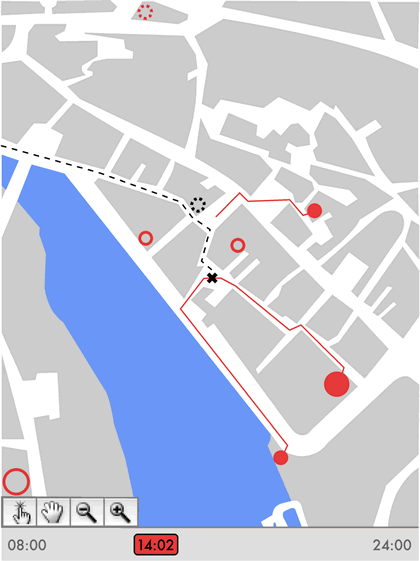
The interface, showing you current position, the status of various destinations, and the opportunities you have to make it to destinations before they close. Paths begin to retreat towards destinations (such as the top red path) when you are unable to make it to a location based on your current location and time.
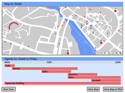
The host's GUI allows the host to suggest particular destinations for the guest, keeping in mind the availability of destinations throughout the day.

Click to launch a preliminary prototype in a new window.
Click to launch an application prototype in a new window.
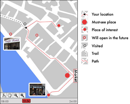
The visitor's GUI with a key to the various symbols. Photos help to connect map locations with real-world landmarks.
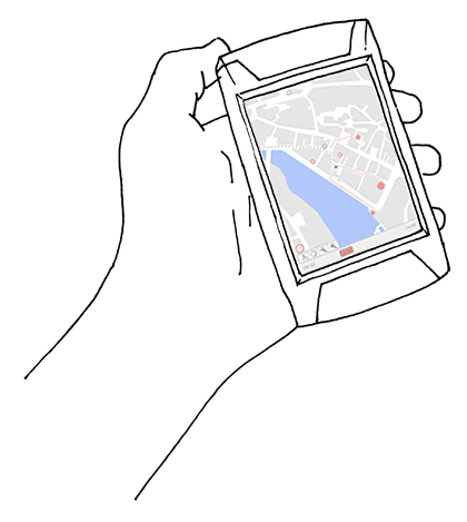
While the host's GUI is tied to a computer screen, the guest can access information on a real-time basis through a handheld device.
Personal Paths enables guests to navigate a host's memories through physical space, providing guests with location and time information to enable better decision-making and agenda prioritization.
Brief Develop a software application to organize a collection of information of your choice.
Project Description Inspired by the fairy tale of Hansel and Gretel, we developed a system in which we create a map containing specific sites (bread crumbs) chosen by a host for a specific guest.
These sites are places the host has gathered over time, and reflect the city from the host's perspective—they are the local hummus place, not the Eiffel Tower. The host adds sites to the system using text messages, Global Positioning System (GPS) information, and photographs.
Using his personal relationship with his guest as a basis for recommendations, the host chooses specific sites for his guest to visit. Our system uses these sites to create a dynamic map which the guest can use on a PDA while walking around the city.
Map Elements This dynamic map encompasses the following elements:
- Locations in physical space
- locations of the sites selected by the host
- the continuously updated location of the guest
- Time
- the current (clock) time
- hours of operation of each location, which may range from all day to only a few hours
- travel times through physical space (how long it takes to get from point A to point B)
These elements determine which sites are available to the guest at any given point in time, based on the guest's location. The map displays this information to the guest using the following conventions:
- An X indicates the guest's current location in the map.
- Dots and circles represent the sites selected by the host:
- Big red dots are must-see places (determined by the host).
- Small red dots are places of interest (determined by the host).
- Dashed black circles indicate places the guest has visited.
- Red circles indicate places that will be available in the future.
- Dashed red circles indicate places that are no longer available.
- A dashed black line indicates where the guest has been (the guest's trail).
- Red lines indicate options available to the guest at a moment in time, based on his location:
- A red line connecting the X to a dot indicates the site is currently accessible.
- A red line disconnected from the X and retreating towards a dot indicates the site is becoming inaccessible. If the guest catches up to the line, he can make it to the site before it closes.
Using our system, a host can create a path through his memories for his guest. However, this path is neither linear nor set: our map creates a dynamic situation in which the guest can choose when and how to access those memories.
Technology All project prototypes were created using Processing, the open source programming language developed at the Massachusetts Institute of Technology Media Lab and Interaction Design Institute Ivrea by Ben Fry and Casey Reas.